Fail:LINE21.jpg
Mine navigeerimisribale
Mine otsikasti
Selle eelvaate suurus: 800 × 552 pikslit. Teised eraldusvõimed: 320 × 221 pikslit | 640 × 442 pikslit | 1000 × 690 pikslit.
Algfail (1000 × 690 pikslit, faili suurus: 102 KB, MIME tüüp: image/jpeg)
Lühikirjeldus
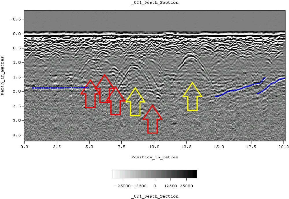
| Kirjeldus | Ground-penetrating radar depth section (profile) collected on an historic cemetery in Alabama, USA. Yellow arrows indicate very distinct reflections, probably associated with human burials. "hyperbolic" reflections, appearing as an inverted U, are typically associated with discrete objects. Less distinct hyperbolic reflections are indicated by red arrows. dashed blue lines indicate horizontal and sloping reflectors, probably bedrock. The many smaller reflections near the surface are likely to be caused by tree roots. Because of the nature of the site, subsurface testing was not conducted, but these interpretations are supported by surface indications (grave markers and depressions) and with line-to-line patterning within the GPR data. |
| Kuupäev | 11. juuni 2007 (algne üleslaadimiskuupäev) |
| Allikas | Projektist en.wikipedia Commonsisse teisaldatud. |
| Autor | Tapatio inglise Vikipeediast |
Litsents
| Autor Tapatio inglise Vikipeediast on andnud selle teose avalikku omandisse. See kehtib üleilmselt. Kui see pole mõnes riigis õiguslikult võimalik: Tapatio annab kõigile õiguse seda teost kasutada ükskõik mille jaoks, ilma ühegi tingimuseta, kui seadus neid just ei sea. |
Esialgne üleslaadimislogi
Esialgne kirjelduslehekülg oli siin. Kõik järgmised kasutajanimed viitavad projektile en.wikipedia.
- 2007-06-11 05:16 Tapatio 1000×690×8 (104839 bytes) {{PD-self}}
- 2007-06-11 04:49 Tapatio 1000×690×8 (104839 bytes) Ground-penetrating radar depth section (profile) collected on an historic cemetery in Alabama, USA. Yellow arrows indicate very distinct reflections, probably associated with human burials. "Parabolic" reflections, appearing as an inverted U, are typicall
Faili ajalugu
Klõpsa kuupäeva ja kellaaega, et näha sel ajahetkel kasutusel olnud failiversiooni.
| Kuupäev/kellaaeg | Pisipilt | Mõõtmed | Kasutaja | Kommentaar | |
|---|---|---|---|---|---|
| viimane | 17. oktoober 2007, kell 20:02 | | 1000 × 690 (102 KB) | wikimediacommons>Conscious | full resolution |
Faili kasutus
Seda faili kasutab järgmine lehekülg: